The next phase of Victoria’s bike network has been unveiled.
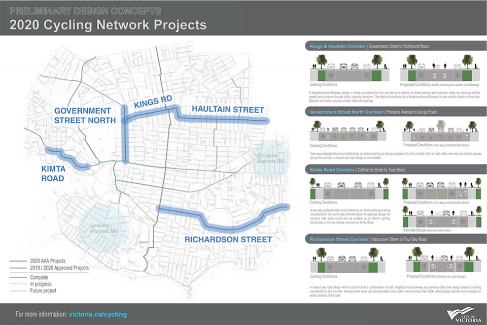
Beginning in 2020, the city aims to design and complete paths along Kings Road, Haultain Street, the northern end of Government Street, Richardson Street and Kimta Road. Proposed designs have now been put forward for public input.
“One of the important things to look for is what is the right level of design treatment for each corridor,” said Sarah Webb, manager of sustainable transportation planning and development for the City of Victoria. “We need to be aware of what’s happening with the land use designations, and what are the kinds of connections we need to make for people walking and biking in the area.”
ALSO READ: Are the Victoria bike lanes too narrow?
The Kings and Haultain corridor would stretch from Government to Richmond streets, and be composed of a shared-use bike way that will see cars and bikes share the same portion of the road. The shared roadway would see “sharrows” or shared-lane markings in the middle of the road, and parallel parking on both sides of the street on many parts of the stretch. Traffic calming options could include a traffic circle, a median divider, curb extensions or a speed hump.
“We will simply be reducing the volumes of cut-through vehicles, vehicle speed and make it a dedicated and designated bike route,” Webb said.
| New designs have been released for the next phase of the Victoria bike lane network. (File contributed/ City of Victoria) |
| New designs have been released for the next phase of the Victoria bike lane network. (File contributed/ City of Victoria) |
The Government Street North Corridor will run from Pandora Avenue to Gorge Road and use one-way protected bike lanes on both sides of the street, buffered by on-street parking.
Part of this section could also involve a Bay Street interim connection of painted bike lanes between Government and Blanshard Streets, which will not be all ages and abilities (AAA) designated, but act as a temporary option until more infrastructure in the surrounding area is in place.
| New designs have been released for the next phase of the Victoria bike lane network. (File contributed/ City of Victoria) |
The Richardson Street Corridor would run from Vancouver Street to Foul Bay Road and utilize shared roadways with painted bike lanes on either side of vehicle traffic. Proposed traffic calming measures include median dividers, speed humps and directional closures.
ALSO READ: Residents seek protected bike lane to connect Victoria and Oak Bay
The Kimta Road Corridor would connect from Robert Street to the Johnson Street bridge in the form of a two-way protected bike lane on the north side. Alternatively, painted bike lanes could go into this space but would require the speed limit to drop to 30 km per hour. This portion would also include an extension of the E&N trail from Robert Street to stretch along Esquimalt Road to Kimta Street.
| New designs have been released for the next phase of the Victoria bike lane network. (File contributed/ City of Victoria) |
Webb added that while designs are in their early stages, the goal is to maintain, if not increase, the amount of parking stalls within the corridors.
There are upcoming open house events scheduled in response to these designs; on Thursday, Dec. 5 from 4 to 7:30 p.m. at the Bayview Presentation Centre at 80 Saghalie Rd., and on Saturday, Dec. 7 it will be held at the Oaklands Community Centre at 2827 Belmont Ave. from 9 a.m. to 12:30 p.m.
For more information visit victoria.ca/cycling.
Like us on Facebook Send a Tweet to @NicoleCrescenziand follow us on Instagram